每个城市都有繁忙的十字路口,汽车、卡车、公交和行人川流不息。他们时常会在这里争抢空间,如此一来,伤亡事故就在所难免。
能不能通过科技手段降低事故率呢?Verizon设计了一个无线传感系统,包括无线网络连接的传感器和摄像机,再结合复杂的算法,分析各色人等在路上的行为,希望以此降低十字路口的风险。
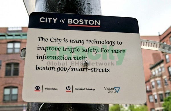
Verizon和波士顿的监管部门进行合作,目前正在该城市进行测试。他们给这个项目命名为“智能街道”(smart-streets program)。
今年3月,Verizon就开始在波士顿最繁忙的十字路口之一,收集汽车、自行车和行人的交通数据。
这个路口选定在马萨诸塞大道交界处,这里有一个四车道、灯塔街(Beacon Street)、一个三车道和一个单行道。附近还有连接波士顿和剑桥的一座主要桥梁。
复杂的路况让这里成为事故多发地。2015、2016年期间,共计16个行人和骑行人在这个路口严重受伤,还有一个骑行人在与一辆平板卡车相撞后死亡。

波士顿交通运输部的主管Vineet Gupta表示,将利用这些信息来设计道路。他们将根据这些数据来决定是否改造道路,比如改变交通信号灯,或者添加一个自行车道。
波士顿的最终目标是在2030年在全市范围内消除交通事故。如果波士顿和Verizon的这个项目可以获得成功,其他城市也可能效仿采取类似的“智能街道”。
此前,波士顿也会常常收集交通数据,但是是采用手动的方式。而且,这里交通管理的设计是依据行业标准,而不是根据本地信息。因此,就可能出现不合理的地方,无形中增加了道路的风险。
在这次尝试当中,为了获得更精确的数据,Verizon在十字路口安装了50个摄像机和传感器,这其中包括四摄像头,每个里面有四个小摄像头监控不同的方向,还有红外照相机,可以做成热成像,可以在雨雪天气识别交通路况。
不光是这些,在地下,Verizon还安装了几十个磁力计传感器,检测路过的各种车辆的速度、数量及型号。这些传感器通过大型金属物体的移动,来记录变化的频率。虽然大多数自行车不能触发磁力计的导电材料,这个地方也有雷达可以遥感骑行人。
Verizon还将两类信息纳入到这个传感器系统,一个是这个城市的各种位置信息,另一个是连接了一个软件,来分辨红绿黄灯是否在给定的时间显示。
该公司的算法会通过解析这些数据流,来寻找触发交通事故的可能性事件,比如说汽车接近自行车道。然后判定这些是否属于波士顿要追踪的12类危险交通行为之一。
监测数据显示,大多数危险交通事件都属于车辆侵入人行道和车行道,没有给行人让路,以及并排停车。
此外,Verizon还统计了闯红灯的汽车和自行车,但是为了减少推行新举措的阻力,而且Verizon公司并非执法机构,因此,这个城市的监管部门承诺,将不会依据Verizon的统计结果开罚单,或进行其他交通处罚。
Verizon公司也表示,在统计数据七天后,将消除这些视频,不保存与任何个人和车辆相关的记录。
由于获得了精确的数据,监管部门可以掌握十字路口的哪些特定地方最容易发生危险交通事件。比如说,初步的调查结果表明,在这个十字路口的西边,汽车始终不爱给行人让路。
显然,监管部门认为这是一次不错的尝试。他们决定把这个项目扩展至另一个马萨诸塞大道的六路口,来了解波士顿中心城区的交通状况。接下来,他们还可能增加传感器,来监测空气质量,希望达到减少污染的目的。
在让城市变得更美好的过程中,我们不能总是拿公民的素质和法律的规定说事,也要想办法来降低守法的门槛。现代化的监测手段,可以让我们更准确地了解一个城市,排查出城市规划中不合理的地方,进而重新设计,来符合当地的自然条件和社会习惯。
作为一个繁华的大都市,波士顿能不能在2030年创造零事故的奇迹呢?让我们拭目以待吧。
Verizon has devised a system of cameras, sensors, and algorithms that can track the number of times cars fail to yield to bicyclists and pedestrians at a particular intersection.
Every city has at least one dangerous intersection where cars, trucks, and buses jostle for space with pedestrians and bicyclists, often resulting in injury, and sometimes death. Could a network of wirelessly connected cameras and sensors, combined with sophisticated algorithms that analyze how people are behaving on the road, make these junctions less hazardous?
Verizon is using Boston as a test bed to find out. In March, the tech giant began collecting car, bike, and pedestrian traffic data at one of the city’s most hectic intersections. Boston will use the information to redesign its streets, says Vineet Gupta, director of policy and planning for the Boston Transportation Department. The data can measure if interventions such as changing traffic signal timings or installing a bike lane have been effective, he adds.
Boston’s ultimate aim is to eliminate traffic fatalities citywide by 2030. If the project is successful, other cities could adopt similar “smart streets” technologies.

The data is being collected at the junction of Massachusetts Avenue, a four-lane road, and Beacon Street, a three-lane, one-way street. The intersection is located near a major bridge that links Boston to Cambridge. Sixteen pedestrians and bicyclists were seriously injured at this crossroads during 2015 and 2016, and one bicyclist was killed after colliding with a flatbed truck.
Recommended for You
-
The Desktop of the Future Is Coming
-
Experts Predict When Artificial Intelligence Will Exceed Human Performance
-
Google Sprinkles AI on Its Spreadsheets to Automate Away Some Office Work
-
Trump Misused MIT Research in Reasons for Ditching Climate Deal
-
You Don’t Have to Major in Computer Science to Do It as a Career
Like other cities, Boston typically collects traffic data manually and bases its traffic-management designs on industry standards rather than local information. To obtain more-accurate data, Verizon outfitted the intersection with 50 cameras and sensors, including “quad cameras”—each containing four smaller cameras that can pan, tilt, and zoom in different directions—and infrared cameras that can do thermal imaging, which is useful for discerning traffic activity in snow and rain. Below ground, Verizon installed dozens of magnetometer sensors that detect the velocity, number, and size of passing cars, trucks, and buses by registering a change in frequency when large metal objects move over them. Since most bikes don’t have enough conductive material to trigger the magnetometers, the site also has radars for sensing bicyclists.
Verizon correlates this sensor data with two other types of information: bus-location data provided by the city and software that can tell whether a traffic light is red, yellow, or green at a given time. The company’s algorithms parse these streams of information and look for “trigger” interactions, such as video footage of a car nearing a bike lane. Verizon then maps those data points to information from other sensors and determines whether it qualifies as one of the 12 complex traffic “events” the company is tracking for Boston. Most of these events relate to vehicles encroaching on crosswalks and bike lanes, failing to yield to pedestrians, and double parking. Verizon also counts the number of cars and bikes that run red lights, but the city has pledged not to use the information to issue tickets or enforce traffic laws. Verizon says it erases its video data after seven days and does not keep any records linked to individual people or vehicles.

The precision of the data enables the city to see which traffic incidents are of most concern in specific parts of the intersection on a day-to-day basis. For example, early results show that cars consistently fail to yield to pedestrians on the western side of the intersection, which is also the area where the bicyclist was killed in 2015.
The city says it plans to extend the smart-streets program to another half dozen intersections along Massachusetts Avenue so it can begin to understand how the road functions as a traffic corridor throughout downtown Boston. It may also add sensors that measure air quality to monitor and eventually reduce pollution.
Will other municipalities follow? Boston’s commitment to reduce traffic fatalities is part of the Vision Zero movement, which originated in Sweden in 1997 and has been adopted by more than 25 U.S. cities, among them Chicago, Los Angeles, New York, San Francisco, and Washington, D.C. Lani Ingram, vice president of Verizon’s Smart Communities division, says she hopes to sell similar systems to those cities. Verizon is currently trialing other smart-city technologies—such as light poles that can broadcast emergency announcements, and Wi-Fi-powered sidewalk kiosks that host information about local events—in Minneapolis; New Rochelle, New York; Sacramento, California; and Seattle.